
Desert Renewable Energy Conservation Plan (DRECP)
& West Mojave (WEMO) Route Network Project (WMRNP)
West Mojave Route Network Project (WMRNP)
Comment Period CLOSED (June 14, 2018)
Federal Register doc 2018-05272
https://www.federalregister.gov/d/2018-05272
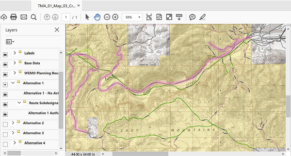
Which twin has the Toni? BLM has made available two versions of maps for public comment on the West Mojave Route Network Project (WMRNP) – georeferenced PDF maps and an online interactive GIS map. Among the numerous problems with both versions is that the two sets of maps do not match. In a screenshot of the online map shown above, the highlighted (pink) route in the Cady Mountains is shown as a motorized route (lime green), but in the same view of the PDF map, the highlighted route is a translinear disturbance (brown).
BLM prepared a Draft Land Use Plan Amendment (LUPA) and Draft Supplemental Environmental Impact Statement (DSEIS) for the West Mojave Route Network Project (WMRNP) within the West Mojave (WEMO) Planning Area of the California Desert Conservation Area (CDCA). A 90-day comment period was opened on March 16th. The WMRNP is a significant component of the DRECP implementation. Read why the WMRNP is important for Rockhounds »
Maps used to finalize motorized routes in California's deserts
found to be severely flawed.
Stakeholders formally ask BLM for 90-day extension.
Read the entire article »
Several stakeholder groups surveyed selected areas within the WEMO boundaries to compare against BLM's maps provided for public comment on the WMRNP. The maps are so flawed that thirty-nine individuals and organizations, including eight rockhounds and one paleontological society, signed onto a letter asking the BLM to extend the comment period an additional 90 days, to September 12th. More time is needed for the public to grapple with the 16,000 miles of routes composed of 300,000 individual route segments (each and every one of which is clickable for comment). There are numerous redundant (overlapping) route segments with unique WEMO ID numbers, which should be consolidated into one set of segments. In addition, there are few labels and there is no separate Rockhound layer to enable hobby collectors to see what routes are relevant to their interest, specficially.
A May 30, 2018 letter prepared by Sheara Cohen et al. asking for an extension of the comment period was rejected by California BLM Director Jerome Perez on June 13th.
Many rockhounds submitted comments before the June 14th deadline, including rockhound advocates who submitted a letter (with attachments) that covered three topics all related to the WMRNP and the comment period process itself, in addition to route specific comments:
- The letter memorializes the authors' communications w/ BLM and problems rockhounds and other stakeholders identified using the maps.
- a. The letter requests fixes to bad/questionable data or data discrepancies, better labeling.
- b. The letter requests an extension to the comment period after BLM fixes the bad data and/or difficult-to-use maps.
- The letter resubmits past comments from WEMO-related and other geographically and subject related projects such as DRECP on gem-mineral collecting areas and route data. It was the impression of many rockhounds that the DRECP comments would be incorporated into the WEMO maps.
It would have been preferable to divide the contents into three separate letters, but given the time available, it was a single submittal. The authors thought it was likely that they were re-submitting information submitted by others previously and already in the WEMO database, but trying to sort out thousands of comments on thousands of miles of routes was beyond their best efforts, so erring on the side of caution lest anything was left out of the maps that should have been included, past submittals to WEMO and other BLM projects were re-submitted for the current DRAFT WMRNP.
Comment period now open on
the draft West Mojave Route Network Project
(WEMO / WMRNP) DSEIS/LUPA
(updated June 6, 2018)
#DRECP #WEMO
Comment Period Deadline: June 14, 2018
Federal Register doc 2018-05272
https://www.federalregister.gov/d/2018-05272
If you want to write you a letter,
email or post it to BLM by June 14, 2018
Be sure to include route numbers and a reason for every comment. (Yes, it seems obvious, but BLM needs a rationale associated with every comment, so be sure to tell BLM you want a route kept open to ensure continued access to X-Y-Z collecting area.)
There are two versions of maps available for comment -- georeferenced PDFs and an interactive online map. Some Stakeholders think it is better to comment on the PDFs. (Be sure to save a back-up copy of whatever you submit to BLM.) More details »
- Bureau of Land Management
California Desert District
Attn: WMRNP Plan Amendment
22835 Calle San Juan de Los Lagos
Moreno Valley, CA 92553 - Written comments also are accepted electronically at: blm_ca_wemo_project@blm.gov
For more information on WMRNP, contact:
Matt Toedtli
Planning and Environmental Coordinator
2601 Barstow Road
Barstow, CA 92311
760-252-6026 or mtoedtli@blm.gov
Visit the BLM web page on the WMRNP comment period »
SOME USEFUL RESOURCES ON DRECP
What's the difference between
a great letter,
a good letter,
and a bad letter »
Want to write your own letter?
Things you should know about DRECP and some tips on making comments »
Why opening DRECP to Review is unnecessary and could be bad for Rockhounds »
What did Rockhounds get in DRECP?
What are the misconceptions about what it did not do?
Download a Rockhound Fact Sheet »
Who opposes the DRECP Review?
Karen Douglas
Commissioner, California Energy Commission (one of the original architects of DRECP)
John Laird
California Secretary for Natural Resources Agency
California Desert Coalition and Bodie Hills Conservancy
Vet Voice Foundation
The Pew Charitable Trusts
Alliance for Desert Preservation (A4DP)
Mojave Communities Conservation Collaborative (M3C)
Newberry Springs Economic Development Association
Lucerne Valley Economic Development Association
Lucerne Valley Museum and History Association
National Parks Conservation Association
… and many other conservation groups
West Mojave Route Network Project
Comment Period Deadline: June 14, 2018
Maps used to finalize motorized routes in California's deserts found to be severely flawed. Stakeholders formally ask BLM for 90-day extension.
Read the entire article »
BLM has prepared a Draft Land Use Plan Amendment (LUPA) and Draft Supplemental Environmental Impact Statement (DSEIS) for the West Mojave Route Network Project (WMRNP) within the West Mojave (WEMO) Planning Area of the California Desert Conservation Area (CDCA). A 90-day comment period was opened on March 16th. Its scope:
"The WMRNP will delineate travel management areas, adopt transportation and travel management strategies, and designate routes on public lands in the WEMO Planning Area. The WEMO Planning Area covers 9.4-million acres of the CDCA in the western portion of the Mojave Desert in southern California, including parts of San Bernardino, Los Angeles, Riverside, Kern, and Inyo counties. The WMRNP applies to the 3.1-million acres of public lands within the WEMO Planning Area."
Several stakeholder groups have surveyed selected areas within the WEMO boundaries to quantify problems observed in the maps the BLM has provided for public comment on the WMRNP. The maps are so flawed that thirty-nine individuals and organizations, including eight rockhounds and one paleontological society, signed onto a letter asking the BLM to extend the comment period an additional 90 days, to September 12th. More time is needed for the public to grapple with the 16,000 miles of routes distributed across 300,000 route segments (each and every one of which is clickable for comment).
Since it is uncertain whether or not the comment period will be extended, notwithstanding the flaws in the maps, it is critically important for Rockhounds to submit comments by the June 14th deadline. (If an extension is granted, there will be opportunity to make supplemental comments.)
Destinations without motorized access will make it impossible for many Rockhounds to visit them. Rockhounds should take note that they should re-submit any comments they may have submitted previously on other projects – even earlier versions of WEMO – to ensure that routes to collecting areas are incorporated into the final plan. Read more details »
Why is the Route Network Plan
important for Rockhounds?
The WMNRP is a critical component of the DRECP for Rockhounds, because its maps incorporate routes to collecting areas. Destinations without vehicular access will make it impossible for many rockhounds to visit them. Rockhounds should review BLM's map data and submit comment letters for routes that are missing or delineated inaccurately to ensure continued access to ther favorite collecting areas. According to the BLM, the best way to make route specific comments is on the WMRNP Online Interactive Map. You can click on individual routes and route segments and submit a comment on the selection. You can also submit comments on ePlanning, which is generally used for the written Environmental Impact Statement (EIS). Please note that there are four alternative plans, which includes one no-action plan. The Preferred Plan is Alternative 4 – this is the plan most likely to be adopted.
Here's the rub. BLM has map data specifically for hobby collecting areas based on inputs from the public (from previous comment periods) and inputs made by former DAC member Kim Erb on behalf of Rockhounds, and inputs made by the agency's own staff. However, the maps made available for the comment period do not include all these data, and what data are available are not readily intelligible as "Rockhound" routes. We have asked BLM's Matt Toedtli to provide maps with the Rockhound-specific layers in time to review them before the comment period closes. According to Toedtli,
"Closer to the release of the Final EIS, tentatively scheduled for October 2019, we will consult with the field office, district and/or state geologist to determine if and how rockhounding sites will be available on public route maps. It may be decided that it is better to release as a separate set of maps, rather than on our route-centric subregion maps."
This is a good response, but to be useful we need the map data to be available during the comment period, not one year or more in the future. We're working on it, stay tuned.
Federal Register doc 2018-05272
https://www.federalregister.gov/d/2018-05272
BLM and conservation groups host meetings on possible DRECP review
April 2, 2018
#DRECP #WEMO
It has been a busy few months, with the BLM posting notices for public comment on Land Use Plan Amendments and related matters which are important for hobby collecting in Southern California. BLM hosted eight meetings at different locations in February and March, where poster sessions and a slide presentation explained BLM's rationale for wanting to revise the DRECP. Curiously, the public was not provided opportunity to speak, but could only provide input to BLM by typing comments into computers provided at the meetings. Although two hours was scheduled for the meetings, at least in Hesperia, people filtered away quickly after the slide presentation was concluded.
Down the hallway from each BLM meeting, a panel discussion was hosted by a consortium of mostly conservation organizations. Overflow crowds spilled out of the small conference rooms – more than 100 people showed up in Hesperia, about 200 came to the meeting in Joshua Tree, and many more came to Bakersfield, which was the best-attended location. The panel sessions had a court reporter to record oral statements for the public record, which it seemed was the thing people most wanted – the chance to be heard and to ask questions. The Hesperia meeting was still going after two hours.
From a recreationalist's perspective, what was most interesting about the panel discussion meetings, was the misperceptions voiced by the public about what DRECP has done to curb their hobby interests. In fact, DRECP did not take away any hobby collecting areas or access to them. To be sure, hobby collecting accommodations have to be spelled out, in detail, in the travel management plans for different areas within the DRECP's boundaries, but it does not require plan-level amending of the DRECP to make such accommodations. (Remember, DRECP is a top-level guideline, it is not itself a travel management plan.) Download a Fact Sheet on what Rockhounds got from the DRECP, misconceptions about what the DRECP did not do, and what amending the DRECP could mean for Rockhounds.
BLM special meeting of
the Desert District Advisory Council (DAC)
Read the report of the March 20, 2018 meeting »
The full transcript of the DAC meeting will be published online, probably in the next two to three months.
Download the DAC meeting agenda »
Download a Rockhound Fact Sheet on what Rockhounds got from the DRECP Record of Decision, misconceptions about what DRECP did not do, and what amending the DRECP could mean for Rockhounds.
What is DRECP?
The Desert Renewable Energy Conservation Plan (DRECP) is the largest land use plan amendment in California state history. It is a 12,000-page programmatic guideline for management planning of federal lands in California's deserts. Its objective is to balance multiple uses and conservation goals with renewable energy (RE) development. Its scope encompasses coordination with private landowners to build RE projects. DRECP is not itself a management plan – it is a top-level guideline for spelling out the details that go into each and every management plan covering different areas within the plan's boundaries. (Rockhounds will have to stay engaged and participate in the preparation of individual management plans as they are developed over the next 25 years.)
After more than eight years of planning and tough negotiation among many Stakeholders who have competing interests over the same areas, DRECP achieved a difficult balance. Like any compromise, no one got everything they wanted, but copius inputs from 50 Stakeholder groups and the public, including 16,000+ letters submitted to DRECP, influenced how the Record of Decision (ROD) was crafted. The ROD was published on September 14, 2016.
DRECP has two parts. Conservation and recreation received first consideration in the Phase I implementation. Within the 22.5 million acres covered under DRECP, 3.6 million acres were designated for recreational uses, including Rockhounding (aka "hobby collecting"). "Development Focus Areas" (DFAs) in the Draft DRECP were modified in the ROD to accommodate recreational uses, including Rockhounding, specifically.
The ROD designated 400,000 acres of DFAs on federal lands for renewable energy. Phase II Implementation focuses on fast-track permitting of 500 renewable energy projects over the next 10 years (from the date of the ROD, 9/14/2016). The California Energy Commission, which is one of the original architects of DRECP, has said this goal is adequate to meet the state's energy needs through 2040.
BLM proposes DRECP Review (FR Doc. 2018-02098, February 2, 2018). BLM is now under enormous pressure from Industry advocates with support from Executive Order 13783 to revise DRECP to create more opportunities for renewable energy development. The California Energy Commission, which was one of the architects of DRECP and helped calculate California's renewable energy needs through 2040, has told BLM that amending the plan is unnecessary. In a March 5th press release, John Laird, California Secretary for Natural Resources Agency, wrote:
"Reopening the plan is a waste of time and resources that will result in uncertainty, delay, and litigation. Reopening will stall renewable energy projects on public lands and impose major new costs on stakeholders without benefit. Instead, BLM should work proactively with the state, local governments, tribal leadership, and other stakeholders to implement the plan effectively and resolve issues with implementation as they arise." [read the whole letter]
The DRECP is here to stay. It will be the prevailing guideline for land use management planning, whether or not BLM's proposed Review goes forward. Either way, BLM is committed to renewable energy development in California's deserts, so Stakeholders concerned with preserving natural features and cultural resources in their deserts can look forward to having to defend them against industrialization well into the foreseeable future.
There is no upside for Rockhounds,
if BLM opens DRECP to Review,
but there is risk of downside.
BLM's goal in amending the DRECP has only one objective: to make available more land for developing industrial-scale renewable energy projects and commercial mining. That will require land designated for other Stakeholders having to to be re-designated for Industry. Doing that is almost sure to unravel the fragile compromise it took eight years of tough negotiation to achieve among 50 Stakeholder groups.
DRECP has only begun to be implemented, so there are no data to provide either quantitative or qualitative references to justify amending the plan at this time, much less to provide help identifying what kind of amending would make sense. While BLM appears to be focusing on conservation designations to achieve its goal, other Stakeholders should not expect to escape unscathed. There is no such thing as surgical targeting when there are 50 Stakeholders involved who are perpetually competing for the same land.
For one thing, opening DRECP to review will not give rockhounds more accommodations than they can ask for currently without a review. However, it could make them vulnerable to losing accommodations or eroding quality of life values they enjoy now. It should be obvious that providing more renewable energy opportunities in or around recreation areas would mean more intrusion of utility-scale projects into unspoiled wildlands and viewscapes that all desert lovers cherish. Conversely, preserving the DRECP means preserving quality of life values, whether you're a resident or a visitor to the desert. The plan preserves the local economies of gateway communities which are powered by a well-managed landscape to support tourism.
Let's not risk shattering the compromises that got Rockhounds what they asked for in DRECP by re-opening it to review at this time.
What DRECP ROD did for Rockhounds
and what it did not do.
There are some misconceptions and inaccurate information floating around the web about the constraints imposed on recreational users by the DRECP ROD. In fact, Rockhounds obtained significant accommodations based on numerous comment letters on the Draft DRECP (2/23/2015), with Development Focus Areas (DFA) and other potential encroachments by possible Industrial projects removed or redrawn where adjacencies or overlaps created potential conflicts. See: Exhibit 2 in SDMG's comment letter at: https://goo.gl/kNbkiM (short URL). Conservation and Recreation were big winners at the expense of Renewable Energy under DRECP's allocations. Recreational designations (SRMA and ERMA) were created which had not existed previously.
Here are some specifics on what Rockhounds got* –
- BLM eliminated at least two proposed DFAs that would have conflicted with rockhounding activities (Lonely Butte and Brown Hill), and has also clarified that rockhounding is an allowable activity in Special Recreation Management Areas (SRMA). Proposed DFAs around Brown Butte and Gem Hill were eliminated to allow continued access to these sites.
- The SRMA in the Amargosa/Grimshaw area was expanded to include Sperry Wash, which is popular for rockhounding. The designated route remains open to allow for responsible access for rock collecting and other recreation activities.
- The DRECP did not close designated routes in the Mojave Trails (Route 66) area, so access remains open to popular rockhounding sites such as Chambless.
- Designation of the Savahia Peak Rock Collection Area along Highway 95 in the Chemehuevi Valley. The management prescription for this area recognizes that "[t]his area is heavily dependent on the use of motorized-vehicles to access the area due to its remoteness, while the recreation action is hiking areas seeking out that one perfect specimen to add to one's own collection." The open designated routes will conform to the Northern and Eastern Colorado Desert Coordinated Management Plan 2002.
- Some SRMAs overlap National Landscape Conservation System (NCLS) lands to provide emphasis on recreational values in management plans. However, where SRMAs do not overlap with NLCS lands, the DRECP still allows for continued use of designated routes for recreational activities that do not conflict with the values of the NLCS lands. (See page II.3-225 of the Final DRECP)
Here are some things DRECP DID NOT DO and does not require a Review to change –
- To date, BLM has not restricted hobby collecting anywhere in DRECP's recreation- or conservation-designated areas, and previously existing routes of access to collecting areas have not been closed. (Drafting of management plans will determine what's permissible where – this is where Rockhounds should direct their focus: provide input during the management plans drafting process.)
- A Review is not required for BLM to accommodate specific recreational uses in conservation-designated areas, for example, Rockhounding is allowed in the Area of Critical Concern (ACEC) in the Cady Mountains, now within the Mojave Trails National Monument.
- To date, not a single open ORV route has been closed under DRECP.
- DRECP does not have to be re-written for BLM to be able to revise its travel management plans.
- To date, no mining claims for locatable minerals of interest to Rockhounds have been rescinded or rejected.
- To date, none of the areas with recreational designations within DRECP's boundaries have been withdrawn from mineral entry.
- The proposed mineral withdrawal of ca. 1.3 million acres within DRECP's boundaries (FR Doc. 2016-31231, 12/28/16) was prompted under the previous administration by some conservation groups concerned with large-scale mining on CDNCL-designated lands. The withdrawal was cancelled on 2/9/2018. (If the DRECP Review goes forward, conservation groups will almost certainly use the opportunity to fight for getting the mineral withdrawal restored.)
- To date, not a single lawsuit against DRECP has been filed.
* Input provided by Shaun Gonzales.
DRECP is here to stay. It will be the prevailing guideline for land use management planning, whether or not BLM's proposed Review goes forward. Either way, BLM is committed to renewable energy development in California's deserts, so Stakeholders concerned with preserving natural features and cultural resources in their deserts can look forward to having to defend them against industrialization well into the foreseeable future.
Under any circumstance, DRECP's implementation must conform with existing federal statutes such as the Federal Lands Policy and Management Act of 1976 (FLPMA)(43 U.S.C. 1714), the National Environmental Policy Act of 1970 (NEPA), the Mining Act of 1872, and other applicable laws.
Some documents and resources on the DRECP Review
Fact Sheet on What Rockhounds got from DRECP and misconceptons about what DRECP did not do (3/13/2018)
Flyer with FAQS on DRECP and tips for writing effective comments on BLM's proposed Review
BLM Press Release on DAC Meeting scheduled for March 20, 2018, Victorville, CA (3/12/18)
BLM's schedule of public meetings on DRECP (2/8/18)
BLM Press Release on DRECP Review (2/1/18)
Federal Register notice on the DRECP Review (2/2/18)
https://www.federalregister.gov/d/2018-02098 (short url)
(Federal Register Document Citation: 83 FR 4921
Docket Number 2018-02098)
Cite this resource: San Diego Mineral & Gem Society. 27 March 2018. DRECP – WEMO. San Diego Mineral & Gem Society, Inc. Available online at: https://www.sdmg.org/sdmg-public/resources/blm-resources/drecp/. Updated 6 June 2018.
When you tweet this article, use the hashtag #DRECP Tweet
or use the hashtag #WEMO Tweet